Native vegetation is defined as vegetation that is indigenous to a given state, including trees, shrubs, understory plants and some specified grasslands 1. The removal of native vegetation for urbanisation and intensive agriculture (e.g. grazing and cropping) has been substantial within the Intensive Landuse Zone in Australia 2.
The extent of catchment clearing was used as an indicator of habitat loss in the assessment catchment condition in Australia, during the National Land and Water Resources Audit 3.

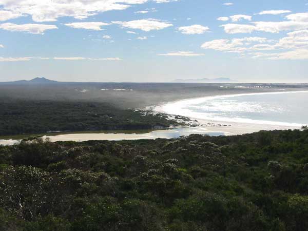
Photo 1. The natural vegetation cover is relatively intact in the lower catchment of St. Mary’s Inlet, WA (photo by Craig Smith).
Coastal issues arising from land clearing
Land clearing fragments the native bush, reducing its biodiversity and destroying its hydrological equilibrium [4,5]. Inorganic nutrient and fine sediment exports increase in response, particularly when the native bush of a catchment has been reduced by 50% 4). Impacts on coastal waterways may include:
- loss of some critical habitats and potential runoff from acid sulfate soils;
- altered environmental flow regimes;
- increased loads of fine sediments;
- increased nutrient loads from both diffuse and point sources, potentially causing eutrophication; and
- increased loads of contaminants from urban stormwater, industrial point sources and agricultural areas.
Existing information and data
Maps showing ‘native vegetation cover’ can be found at the Catchment Condition Online Maps website at Agriculture, Fisheries & Forestry Australia 2. Appendix I (pp. 311-312) in Volume 2 of the Australian Catchment, River and Estuary Assessment, 2002 contains a map of Australia’s River Basins and Drainage Divisions in which each river basin has been assigned a number. These catchment numbers can be matched to a large number of coastal waterways in pages 316-363 of the same document. The per cent native vegetation cover for the river basins is available in Appendix B (pg 65-76) of the Assessment of catchment condition in Australia’s intensive land use zone : a biophysical assessment at the national scale / Joe Walker, Simon Veitch. 3 . The extent of catchment clearance is a parameter in the Simple Estuarine Response Models developed by CSIRO.
More information on the importance of native vegetations can be found at the Australia’s Native Vegetation Website at Environmental Australia.
- NSW Department of Land and Water Conservation 1997. Definitions and Exemptions, State Environmental Planning Policy No. 46, Protection and Management of Native Vegetation, Amendment No. 2, pp. 26. ↩
- Catchment Condition Online Maps website at Agriculture, Fisheries & Forestry Australia. ↩ ↩
- The assessment of catchment condition was conducted as a partnership between the Audit, the Bureau of Rural Sciences and CSIRO Land and Water with support and involvement of State and Territory natural resource management agencies. The final report (Project 7/8) to the National Land and Water Resources Audit by Walker, J., Veitch, S. Braaten, R., Dowling, T., Guppy, L., Herron, N (2001) is entitled Assessment of Catchment Condition in Australia’s Intensive Land Use Zone: A biophysical assessment at the national scale and is found at the following website Assessment of catchment condition in Australia’s intensive land use zone : a biophysical assessment at the national scale / Joe Walker, Simon Veitch. ↩ ↩
- Harris, G.P. Simple rules underlie the complex and non-linear dynamic of terrestrial and aquatic ecosystems: Implications for catchment biogeochemistry and modelling. CSIRO Land and Water technical Report 11/02, April 2002. (http://www.clw.csiro.au/publications/technical2002/tr11-02.pdf ↩


